

![]()
The Rio Tahuayo, located at 73º13'W longitude and 14º12'S latitude, is a right tributary of the Río Amazonas (Fig. 1). The study area is composed of seasonally flooded forest called "bosque de tahuampa" [Prance, 1979; Encarnación, 1985] or alluvial forest class I according to the terminology used by Malleux [1975].
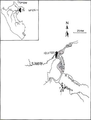 |
During the highwater season (February to May) the river is composed of white to mixed water [Sioli, 1974; Encarnación, 1985] that floods the forest, leaving a layer of new soil on the ground. The forest is low and very disturbed by lumbering. In general, the discontinuous woody vegetation reaches only 2025 m in height, due to the logging of the large tree species. In the vicinity of Punga, the forest occurs on hillsides or "upland terra firme" [Cain et al, 1956], nonflooded land called "bosque de colina o de alturas" by Encarnación [1985]. The animals in both forest types are subject to high hunting pressure, but this does not include Aotus . Between 1978 and 1979, the CRCP staff trapped 11 specimens of Aotus in the "bosque de tahuampa" near Caserío Huaisi. Fig. 1. The geographical location of the study area. |
