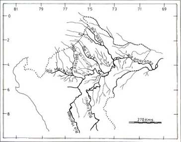

The study area, in the Peruvian lowland Amazonia, lies between 71º20'75º54' west longitude and 01º25'06º16' south latitude, and 120 to 300 s.l.m. The principal types of forests within the region, as defined by Malleux [1975] and Encarnación [1985], are the lowland, or floodable, forest and highland, or nonfloodable, forest.
Lowland forests characterize the basins of the lower Rio Tahuayo, Rio Ampiyacu, lower Nanay, ChambiraNanay, Nucuray, Uritoyacu, ChambiraMarañon, and YanayacuMarañon (Fig. 1). The soil, old alluvial deposit, is wet. The ground is flat and during flood periods is inundated by black, white, or mixed waters. The vegetation includes tall trees about 40 m in height with thick trunks and spreading crowns.

Fig. 1. Northeastern Peru, showing the areas censused of Aotus : 1, R. Cochiquinas; 2, R. Ampiyacu; 3, R. Orosa; 4, R. Apayacu; 5, R. Maniti; 6, R. Bajo Nanay; 7, R. Alto Nanay; 8, R. ChambiraNanay; 9, R. PintoyacuNanay; 10, R. Tigre (left bank); 11, R. Tigre (right bank); 12, Qda. YanayacuMarañon; 13, R. ChambiraMarañon; 14, R. Uritoyacu; 15, R. Nucuraray; 16, R. PavayacuNucuray.
Highland forests characterize the basins of the Ríos Maniti, Apayacu, Orosa, Cochiquinas, upper Nanay, PintoyacuNanay, and Tigre (Fig. 1). The soil is clayey and the ground rolling, with slopes of 5% to 20% and with heights to 30 m [Malleux, 1975]. Inundations during high flood levels are from whitewater rivers. The dominant hardwood trees, 3040 m in height, have mostly narrow trunks and nonspreading crowns. Highland forest has been more heavily lumbered and deforested than lowland forest, for conversion to agricultural and cattle raising land.
Neither of the forest types in the regions censused had been subjected to recent cropping for Aotus prior to our studies. Hunting pressure is high although Aotus is excepted owing to its small size and nocturnal habits.
